
Highlights
- Cross Val d'Hérémence's alpine meadows
- Breathe in the fresh Alpine air
- Stay the night in high mountain huts
- Enjoy views of the Turtmann & Brunegghorn Glaciers
- Make friends with the spotted Herens cows
Brief Itinerary
| Day | Highlights | Overnight |
|---|---|---|
| Day 1 | Arrive in Geneva & Transfer to Sion | Sion |
| Day 2 | Sion – Thyon 2000 – Col de Prafleuri Pass – Prafleuri hut | Prafleuri Hut |
| Day 3 | Prafleuri Hut - Col des Roux & Col de Riedmatten Pass - Arolla | Arolla |
| Day 4 | Arolla - Col Torrent Pass & Lake Moiry - Zinal | Zinal |
| Day 5 | Zinal - Col de la Forcletta Pass - Grüben | Grüben |
| Day 6 | Grüben - Augstborg Pass - St. Niklaus - Zermatt | Zermatt |
| Day 7 | Depart Zermatt |
Detailed Itinerary
Day 1: Arrive in Geneva & Transfer to Sion

Fly into Geneva, then transfer to Sion in the Valais Valley. The best way to get here is by train, which goes directly from Geneva's city center into the mountain valley. Alternatively, you can request a private transfer. Upon arriving in Sion, check into your hotel where you will receive your travel pack with all of the information you need for the tour.
Although the city of Sion itself isn't that special, its location at the center of the Valais Valley makes a hub for hiking and trekking in the Alps. Surrounding it are some of Switzerland's biggest glaciers and highest mountains, giving the city a dry climate. As a result of this, the city is surrounded by crops and vineyards; it's worth tasting some of the local wine if you get the chance.
Day 2: Sion – Thyon 2000 – Col de Prafleuri Pass – Prafleuri hut

Start your morning on the bus from Sion to Thyon 2000 (a small ski resort) where your hiking begins. As you're already at high altitude, your hike today will stay on a balcony alongside the mountain range as you cross Val d'Hérémence's alpine meadows. You're heading for Lac de Dix to the south, but take a right at the last uphill ascent to reach Prafleuri Hut.
Elevation change: +2,297 ft (700 m), -656 ft (200 m)
Hiking time: 5 hrs 30
Day 3: Prafleuri Hut - Col des Roux & Col de Riedmatten Pass - Arolla

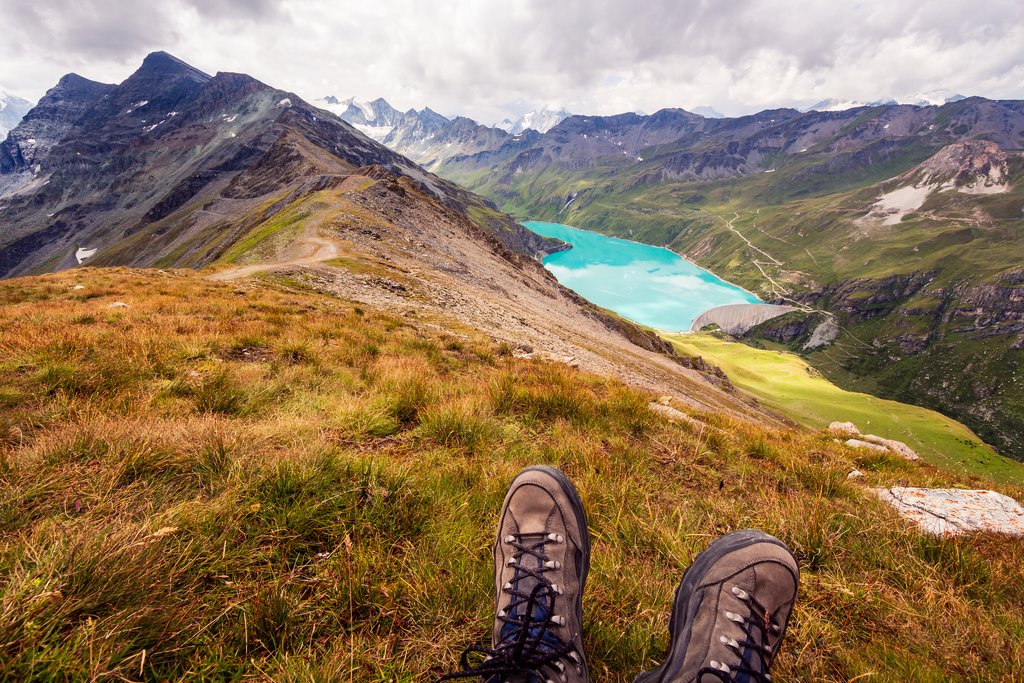
Get an early start to ascend to Col des Roux Pass this morning. You'll follow a balcony trail above Lac des Dix (a 745 ft (227 m) deep lake formed by the Grande Dixence Dam) to reach the foot of your next ascent, this time up to Col de Riedmatten Pass. The pass ends in a gully, with hand cables installed alongside the trail for safety.
Once you've gotten over the pass you'll hike down to Arolla in the Herens Valley, a picturesque village that gets its name from the Arolla pine. You'll spend the night here, surrounded by flower-decorated Swiss chalets and Herens cows.
Elevation change: +2,461 feet (750 m), -4,331 feet (1,320 m)
Hiking time: 7 hours
Chat with a local specialist who can help organize your trip.
Day 4: Arolla - Col Torrent Pass & Lake Moiry - Zinal

Start off with a transfer to Les Haudères and Villa. Leaving Villa, you'll hike through flower-covered alpine meadows to the Col de Torrent Pass. Pass Lake Autannes and continue all the way to Lac de Moiry (another dammed lake). Once you reach the lake, you can choose whether you want to continue on foot via Corne de Sorebois or take a bus from the Moiry Dam to your evening accommodations in Zinal.
If you choose to take the bus it's worth stopping in the village of Grimentz, considered to be one of the Swiss Alps' nicest villages with dark wooden houses and hand-carved ornamentation.
Elevation change: +3,937 feet (1,200 m), -2,198 feet (670 m)
Hiking time: 5.5 hours
Day 5: Zinal - Col de la Forcletta Pass - Grüben

Leave the Anniviers Valley today as you hike toward the Forcletta Ridgeline and Col de la Forcletta Pass. This scenic vantage point sits high above the pastures of Turtmanntal and the Grüben Valley, while still down the valley from the Turtmann and Brunegghorn Glaciers, giving you views of some of the area's 13,123-foot (4,000 m) peaks.
The Turtmann Valley is the most remote in the Valais/ Wallis region, and less frequented by hikers. At the south end of the Valais sits one of the most famous and easy to summit peaks—Bishorn.
Stay the night in Grüben in the valley, a tiny town with only one accommodation option for trekkers.
Elevation change: +3,937 feet (1,200 m), -3,445 feet (1,050 m)
Hiking time: 7 hours
Day 6: Grüben - Augstborg Pass - St. Niklaus - Zermatt

Start the day with a hike up to the mountainside chalets above Grüben. Then hit Augstbord Pass, an easy, high perch that marks your trip's last section at altitude. Once you're downhill, you'll find yourself in Jungu, a remote village that can only be reached by foot or aerial tram. It's a traditional Swiss village, surrounded by expansive pastures and aging wooden barns, with views of the Dom de Mischabel range (the third-highest summit in the Alps).
Take the aerial tram from Jungu to St. Niklaus, the first village in the valley toward Zermatt. Spend some time exploring, then take the half-hour train to Zermatt in time for dinner. Spend the night in Zermatt.
Elevation change: +3,773 feet (1,150 m), -2,953 feet (900 m)
Hiking time: 5 hours
Day 7: Depart Zermatt

Enjoy one last alpine breakfast before you catch your transfer to the airport (or onward to your next adventure).
To see more great European trekking itineraries, see kimkim's round-up of Europe's best hut-to-hut hikes.
Map
